Department of Geography, University of Kentucky
817 Patterson Office Tower
Lexington, Kentucky 40506
Cartographer and mapping technology instructor. 15+ years of creative teaching and course development and 25+ years of map publishing, web design, and GIS consulting. Creates challenging and rewarding experiences learning open-source mapping, production cartography, and field mapping techniques. Current research uses lidar, digital elevation models, and terrain analysis.
M.A., Geography. 1999
Thesis: The Daily Aesthetic [http://www.uky.edu/Projects/TDA]: A Multimedia Exploration of Leisure and Recreation in Lexington’s Segregated Park System
B.A., Major in Geography, Minor in Studio Fine Arts and Mathematics. 1994
Thesis: Abandonment and Generation: Technology & Culture in Indiana Public Parks
| 2024–present | Department of Geography, University of Kentucky |
Instructor for in-class undergraduate classes and online graduate Digital Mapping program. Responsibilities include teaching and developing a curriculum using open-source and ArcGIS mapping software and libraries. Focus on lidar and web mapping applications.
Courses taught
| 2018–2024 | Department of Geography, University of Kentucky |
Courses taught
Example MAP 671 module from 2018
| 2008–2018 | Department of Geography, University of Kentucky |
Instructor for in-class undergraduate classes. Mapping courses focus on ArcGIS and Python and open-source GIS platforms. Created content for all courses.
Courses taught
Example GEO 409 class project
| 2013–2017 | College of Agriculture, University of Kentucky |
Instructor for field-based GIS applications. Course uses mobile GPS apps, ArcGIS, and Lidar and NAIP datasets to measure tree canopy and 3D attributes in our areas of interest. Created content for all courses.
Example NRES 355 class project
| 2006–2013 | Bluegrass Community and Technical College |
In-class and online instructor for introductory geography classes.
Courses taught
2023 Cartography in the Bluegrass
Co-organizer (with Rich Donohue) of event to showcase work by local cartographers.
2019-2020 maptimeLEX series
Co-organizer (with Rich Donohue) of monthly workshops on open-source mapping tools and techniques.
2017 “Fundamentals of QGIS” and “Raster processing and tileset creation with QGIS”
Kentucky Association of Mapping Professionals Annual meeting, September 5.
2017 “Fundamentals of QGIS” and “Raster processing and tileset creation with QGIS”
Kentucky Association of Mapping Professionals Annual meeting, September 5.
2017 “Introduction to QGIS Short Course”
University of Kentucky Department of Geography and Kentucky Association of Mapping Professionals, June 27.
2016 “Map Making with QGIS” and “Learning the Basics of CARTO”
Kentucky Association of Mapping Professionals Annual Meeting, October 18.
2016 and 2015 “UKy Summer Map Camp”
University of Kentucky Department of Geography, Summer.
2025 “Inside Outside: Entangled boundaries in Kentucky’s city and wilderness public parks” 2nd Story Gallery, Lexington, Kentucky, July 24.
2025 “Sun & hill: topographic methods” University of Kentucky Department of Geography Colloquium Series, February 14.
2024 “Visualizing landscape dynamics: Surface change detection using multi-temporal DSMs” Kentucky Association of Mapping Professionals annual meeting, October 9.
2024 “Open-source 3D maps in the browser.” University of Kentucky Earth and Environmental Sciences Department Rast-Holbrook Seminar Series, September 19.
2023 “Open-source 3D maps in the browser.” Kentucky Association of Mapping Professionals annual meeting, October 11.
2023 “Showcasing a GEO509 student project.” Cartography in the Bluegrass, September 28.
2022 “How we use QGIS at UKy Geography.” Kentucky Association of Mapping Professionals GIS Day event, November 16.
2022 “The joy of mapping with Boyd.” University of Kentucky Department of Geography Colloquium Series, October 28.
2022 “Shaded reliefs from lidar derivatives.” Kentucky Association of Mapping Professionals annual meeting, September 28.
2019 “Open source command line GIS.” North American Cartographic Information Society annual meeting, October 18.
2019 “Lidar: Processing & visualization with Python and ArcGIS Pro.” Kentucky Association of Mapping Professionals annual meeting, October 11.
2019 “Weather mapping in HD: a season of Kentucky sunsets.” University of Kentucky Department of Geography Colloquium Series, February 15.
2017 “Teaching experiences at the University of Kentucky.” Department of Geography Colloquium Series, December 8.
2010 “Great Smoky Mountains: A 2nd Edition.” Kentucky Association of Mapping Professionals Quarterly Meeting, August 5, 2010.
2009 “The Sheltowee Trace Trail Map.” Appalachian Studies Association Annual Conference, March 27-29.
2008 “The Great Smoky Mountains Trail Atlas.” Appalachian Studies Association annual conference, March 28-30.
2007 “The Great Smoky Mountains Trail Atlas,” map presentation. North American Cartographic Information Society annual meeting, October 12-15.
2006 “The Big South Fork Trail Guide.” map presentation, GIS Day University of Kentucky, November 15.
2005 “Mapping Recreation with GPS, GIS, and Cartographic Art,” University of Kentucky Department of Geography Colloquium Series.
2004 “The Sheltowee Trace.” Kentucky GIS Annual Conference, September 24-28.
2002 “Animated Maps,” GIS Day University of Kentucky, November 14.
2001 “outrageGIS mapping.” Southeastern Division of the Association of American Geographers annual conference, November 17-20.
1998 “A Douglass Park Documentary Project.” University of Kentucky Department of Geography Colloquium Series.
1996 “The Daily Aesthetic.” Southeastern Division of the Association of American Geographers annual conference.
| Spatial apps | Programming | Design |
|---|---|---|
| QGIS, ArcGIS, PostGIS | JavaScript, Python, Bash | HTML/CSS, Adobe Creative Cloud |
| 1998–present | outrageGIS mapping |
Creating printed and online maps that help hikers, mountain bikers, and equestrians better navigate public trails and wilderness areas: outrageGIS mapping
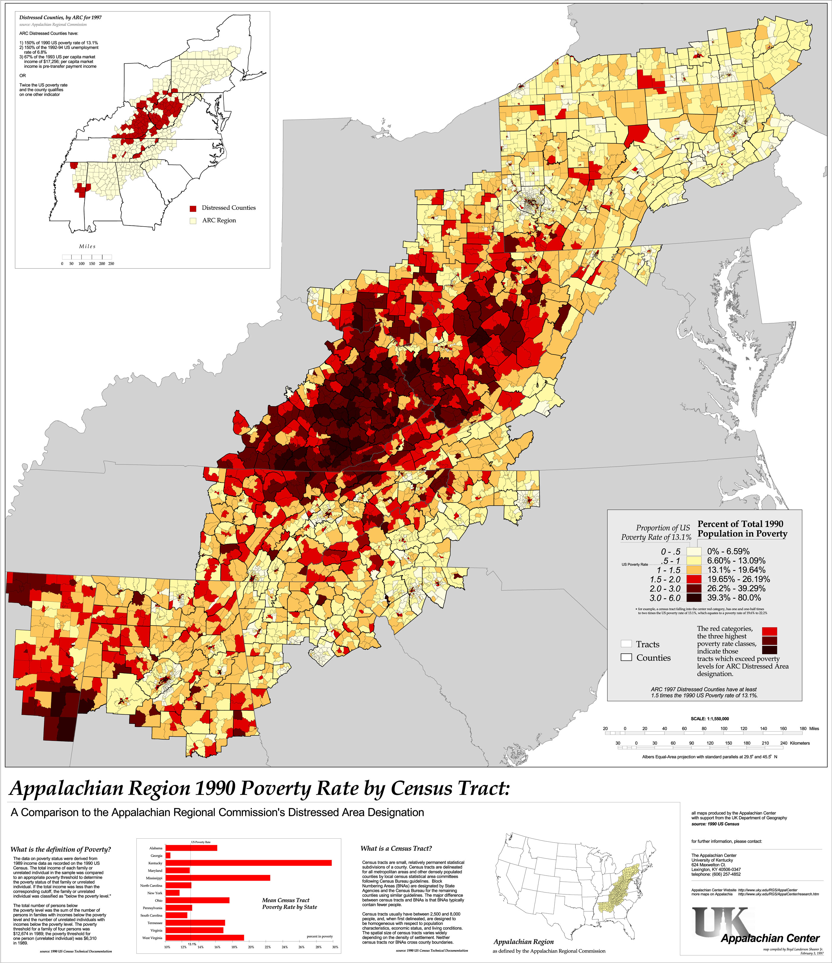
| 1995-1999 | Appalachian Center at the University of Kentucky |
Created thematic maps analyzing demographic trends in the Appalachian region. Focused on patterns of social and infrastructural distress at the census tract level of geography. Example publication from 1997, Appalachian Region Poverty Rate by Census Tract.
A selected list of published print maps.
2006 “First Frontier Audio Driving Tour”
Commissioned by the Southern and Eastern Kentucky Tourism Development Association, 144 minutes. Writer, producer, and editor.
Audio Disk 1 | Audio Disk 2 | Example map
Town Branch Trail, Inc; Board Member
Kentucky Association of Mapping Professionals
North American Cartographic Association Society
June, 2025